


MacKay River Hydrological Profile
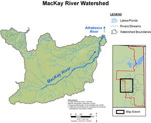
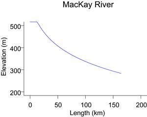
The MacKay River enters the Athabasca River from the west, near Fort McKay. The MacKay River drainage basin covers an area of approximately 5,570 km². The flow originates in the north slopes of the Thickwood Hills at an elevation of approximately 520 m; the basin also includes the plateau and south slopes of the Birch Mountains.
Flows for the MacKay River near Fort MacKay are recorded by WSC (WSC station 07DB001) for the open-water season (March to October). Additional information is collected by RAMP (RAMP station S26) from October to February. The MacKay River tends to experience high flows in the spring due to the combination of snowmelt and precipitation, and in some years experiences maximum daily flows in summer due to rainfall events. Lowest recorded flows tend to occur in the winter. The highest recorded daily flow of 339 m³/s occurred on May 6, 1985. The lowest recorded flow of 0.023 m³/s occurred on March 2, 1973.
Online Hydrographs
View online hydrographs of the MacKay River in the Interactive Features section.