Athabasca River Hydrological Profile
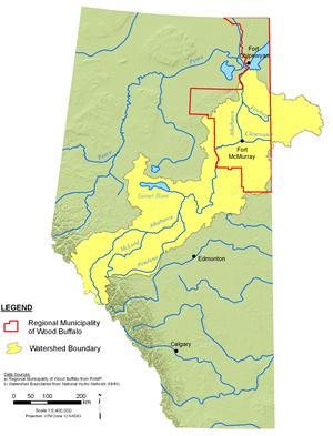
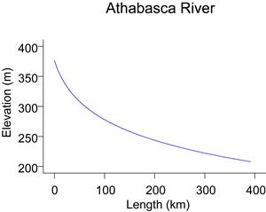
The Athabasca River drains an area of approximately 138,000 km², and flows nearly 1,400 km from its headwaters to the Peace-Athabasca Delta and Lake Athabasca. The Athabasca River system includes a total of 94 rivers, over 150 named creeks, numerous unnamed creeks, and 153 lakes (Science Outreach 2007).
As a major river system, the Athabasca is influenced by a variety of climate, terrain and landscape characteristics found within its basin. The seasonality of climatic conditions is a major influence affecting river flow conditions. The climate includes cold winters, when most of the seasonal precipitation falls as snow. Cold winters are typically followed by warm summers, when snow and glacial melt waters from the river’s headwaters combine with runoff from localized snowmelt and rainfall events throughout the basin. As the river flows toward Lake Athabasca, water is contributed to the river from individual sub-basins. Up-to-date discharge and climate can be accessed at the AENV website and the WSC website.
The Athabasca River is unregulated, which means that flows are not controlled by a dam. Hydrometric monitoring stations located in the headwaters (at Jasper), mid-river (at Athabasca) and lower river (at Fort McMurray) have been operated by the Water Survey of Canada (WSC) since the 1960s. The mean annual discharge of the Athabasca River at these monitoring stations is 2,790,000 dam³, 13,600,000 dam³, and 20,860,000 dam³, respectively, indicating the increasing discharge with progression downstream (AENV 2008).
In the oil sands region, the Athabasca River experiences low flows in late winter, with a minimum daily flow of 88.6 m³/s recorded on January 18, 1988 at the WSC station 07DA001 (at Fort McMurray). Peak flows at this location tend to occur in late June or July. A maximum daily flow of 4,700 m³/s was recorded on July 15, 1971.
Online Hydrographs
View online hydrographs of the Athabasca River in the Interactive Features section.


