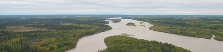
Clearwater River Hydrological Profile
The Clearwater River at Draper drains an area of approximately 30,800 km². Broach Lake in Saskatchewan, at an elevation of 460 m, forms the headwaters of the Clearwater River. In the upper reaches the river flows over Precambrian shield. The middle reaches meander through the interior plains, and further downstream in the lower reaches, the river system is characterized by high valley walls of limestone and dolomite.
Hydrometric data has been collected by WSC at station 07CD001 (Clearwater River at Draper) since 1958. Daily flows for the period of record have ranged from a maximum of 790 m³/s on April 30, 1974 to a low recorded value of 26.2 m³/s on February 19, 1982. High flows often occur in spring as snowmelt combined with spring rainfall results in seasonal high (peak) flows. Floods have also been recorded in the summer months due to extreme rainfall events within the drainage area. Low flows generally occur in winter, when precipitation is stored as snow. In some years, another low flow period may occur during late summer due to dry conditions throughout the watershed. However, for the period of record, the annual minimum daily low flow has always occurred in winter months for this location.
Granted Canadian Heritage River status both in Alberta and Saskatchewan, the Clearwater River is largely a natural river system. The lack of significant oil sands developments means that the Clearwater River can be used as a baseline river system to provide information on the variability and characteristics of natural systems.
Online Hydrographs
View online hydrographs of the Clearwater River in the Interactive Features section.