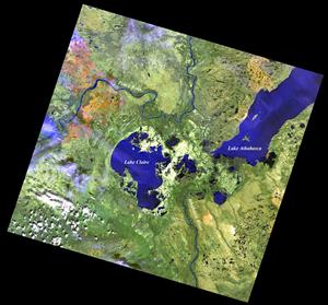


Lake Athabasca and the Peace-Athabasca Delta
Lake Athabasca and the Peace-Athabasca Delta are perhaps the most ecologically rich areas of the Athabasca River basin. The unique geographical features and ecological importance of this area are internationally recognized, and portions of the delta and lake basin now lie within national and provincial protected areas. This section describes the geographical characteristics of Lake Athabasca and the Peace-Athabasca Delta, and provides an overview of the flooding that is essential for maintaining the ecological character of the Delta.