


The Peace-Athabasca Delta
Deltas are formed where rivers flow into a lake or the sea. As a river enters a larger body of water, its flow decreases and sediment particles that had been suspended in the water settle to the bottom. Over time, these sediment deposits build up, forming bars, islands, or peninsulas that divide the river into channels that extend across the new delta plain (PADPG 1972).
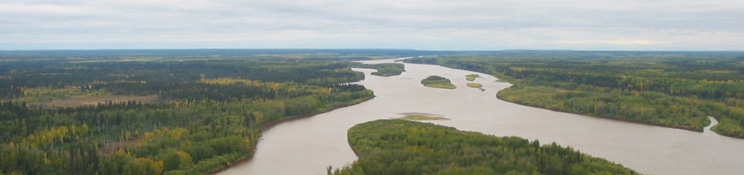
The Peace-Athabasca Delta is located at the western end of Lake Athabasca, and was formed over thousands of years from the deposition of sediment carried by the Athabasca and Peace rivers. The Delta is bounded by the Birch Mountains in the southwest and by the Caribou Mountains in the northwest, and lies west of the Canadian Shield (PADPG 1972). The Peace-Athabasca Delta actually consists of three smaller deltas: the Athabasca River delta (1,960 km2), the Peace River delta (1,680 km2), and the Birch River delta (168 km). River channels that meander across the delta drain upland areas and connect its major lakes—Claire, Baril, Mamawi, and Richardson—to Lake Athabasca (Prepas and Mitchell 1990). Because of its flat topography, the delta is very sensitive to small changes in water level in Lake Athabasca. Perched basins—with surface levels higher than the surrounding water level—are separated from groundwater by impermeable surfaces, and are dependent on flooding for replenishment of water.
While today the Peace River is contained within the banks that have formed from the long-term deposition of sediment, the Athabasca River delta is still considered active, and is encroaching further into Lake Athabasca. Deposition of sediment from the Athabasca River formed Lake Mamawi as well as the southern and eastern shores of Lake Claire, a former bay of Lake Athabasca (PADPG 1972). Similarly, the Birch River, draining into the western end of Lake Claire, is still depositing sediment over its delta, which is expanding into Lake Claire (PADPG 1972).
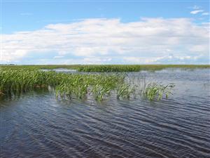
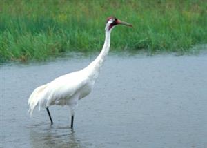
The Peace-Athabasca Delta is the largest boreal delta in the world, and the varied habitats found in the delta—including shallow lakes, mud flats, fens, meadows, and forest, for example—support at least 215 species of birds, 44 species of mammals, 18 species of fish, and thousands of species of insects and invertebrates (Wetlands International 2008). The delta contains some of the largest undisturbed grass and sedge meadows in North America; these meadows support approximately 5,000 Wood and Plains Buffalo (Environment Canada 2008). The delta is also one of the most important waterfowl nesting and staging areas in North America. All four major North American flyways cross the delta (Wetlands International 2008). Breeding ducks and geese on their way to the Mackenzie River lowlands, Arctic river deltas, and Arctic islands use the delta as a staging area, with up to 400,000 birds found in the delta in the spring and over one million birds present during the fall. The delta is the nesting area for the only known breeding population in central Canada of the vulnerable Peregrin Falcon (Wetlands International 2008). Because of its ecological and habitat value, the Peace-Athabasca Delta has been designated a wetland of international importance under the Ramsar Convention.