The Distribution of Boreal Forests
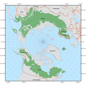
Worldwide, the boreal forest covers 12 million km2 and accounts for about 1/3 of the planet's forests, making it one of the largest biomes in the world (Lakehead University 2007). Found between 50° and 60° northern latitude, just south of the Arctic circle, the boreal forest stretches over the northern hemisphere in a large, circumpolar band across Canada, Alaska, Russia, and Scandinavia.
In Canada, the boreal forest occupies about 35% of Canada’s total land area and 77% of Canada’s forested land, stretching across the country from the Yukon Territory to Newfoundland and Labrador. To the north of Canada’s boreal forest lies the treeline and Arctic tundra, and to the south lie the subalpine and montane forests of British Columbia, the grasslands of the Prairie provinces, and the Great Lakes-St. Lawrence forests of Ontario and Quebec (NRCAN 2004). Boreal forest is the largest single ecosystem in Canada (NRCAN 2004), and accounts for almost 25% of the world’s remaining intact forests (DUC 2008a).
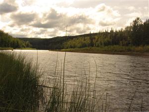
The boreal forest is the largest natural region in Alberta. The boreal forest covers the northern half of the province, and includes broad, lowland plains and localized extensive hill systems. Alberta’s boreal forest includes great swaths of coniferous forest, large areas of aspen parkland (near Grande Prairie, Peace River, and Fort Vermilion), large rivers, lakes, and an extensive network of small streams, muskeg, and other wetlands (Heritage Community Foundation 2008).
The distribution of the boreal forest has changed over millennia in response to changes in climate and the movement of large ice sheets. The southern advance of glacial ice in the past pushed the forest to the south, while the retreat of the ice saw the forest migrate northwards. Fossil records around the world show how the forest has 'travelled' over the millennia (Lindsay and Simmons 2002). The future distribution of boreal forests will depend on how quickly these hardy forests can adapt to a changing environment.


